Orthomosaic Imagery
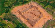
Detailed, stitched aerial images for site overviews, visual comparisons, and project documentation.
COMMERCIAL DRONE SERVICES / CENTRAL TEXAS
High-resolution aerial imagery and practical site data to support planning, progress tracking, and project documentation.
A CLEARER VIEW OF YOUR PROJECT
Drone mapping helps project teams see an entire site, document changing conditions, and communicate progress with consistent visual records.
We tailor flight planning and processing to your project requirements, then deliver imagery and data products suited to your workflow.
WHAT WE DELIVER
Available deliverables depend on site conditions, project scope, and the accuracy requirements agreed upon before the mission.
Detailed, stitched aerial images for site overviews, visual comparisons, and project documentation.
Surface and terrain representations to support planning, visualization, and site analysis.
Contour visualizations derived from processed elevation data where site conditions support them.
Estimated material volumes to assist with inventory tracking and earthwork progress reporting.
Repeatable aerial views and organized imagery for construction milestones and as-built visual records.
WHERE MAPPING HELPS
Track grading, material movement, and site changes across project milestones.
Capture current site conditions for planning discussions and progress records.
Document large sites, access roads, parking areas, and property improvements.
Share clear aerial visuals with owners, contractors, and distributed teams.
HOW IT WORKS
Define the project area, intended uses, and deliverables.
Review site access, airspace, conditions, and collection needs.
Capture overlapping imagery using a mission-specific flight plan.
Prepare and deliver the agreed-upon imagery and mapping products.
LET'S DISCUSS YOUR PROJECT
Tell us where the project is located and what information you need. We'll help define a practical scope.